
Maple Pass Loop

[North Cascades National Park, Jul 15, 2018]
With my Ragnar race now over, the actual vacation part of my trip finally began! On the agenda for the day was a trip into North Cascades National park. This very wild and undeveloped park is a haven for the backcountry hiker, but there are some great trails for day hikers as well. It has over 300 glaciers, the greatest concentration in the US outside of Alaska.
The park is remote and we had a 2-hour drive ahead of us from our hotel in Everett, WA. I would normally stay as close as possible to the entrance to save time, but I didn’t have the option in this case. We also got a late start because I wanted to finally get some sleep after the race. We watched part of the soccer World Cup final between France and Croatia while eating breakfast at our hotel. We were rooting for Croatia, but it wasn’t meant to be.
We were spending the next night in Burlington, about 30 minutes north of Everett. Since it was on our way and I preferred not to have all of our luggage in the car with us in case we went hiking, we stopped by the hotel first to drop off it off. With sunset in Washington around 9 pm this time of year, we had plenty of daylight hours to explore.

We picked up Highway 20, also known as North Cascades Highway, just North of Burlington. This highway is the northernmost route through the Northern Cascades, and it’s usually closed in the winter due to snow and avalanche danger.


Highway 20 is part of a 400-mile driving loop that takes you through both the North and South Cascades, aptly named the Cascade Loop. I had planned our trip around Washington’s national parks, but driving this loop is definitely another option for a great experience of Washington.
Highway 20 follows the Skagit River and starts out in flat farmland.


As I was reading my guidebook, I mentioned one of the towns we were going to pass by in Skagit Valley called Concrete. B, a movie fan with exceptional memory, told me that Concrete was the town featured in the 1993 movie This Boy’s Life starring Robert De Niro and a very young, yet to be discovered Leonardo Di Caprio. He was telling me about a giant cement silo stamped with the town’s name and prominently featured in the movie when, low and behold, we saw that exact structure right across from the gas station we had just so happened to stop at. Thanks, universe! Concrete was once home to the largest cement plant in the state, hence its name.


Continuing east, we left civilization and entered the national park. We had to take some photos at the sign, of course.

Continuing on highway 20, we started the slow and steady climb into the North Cascades. The visitor center is near the small township of Newhalem.
We stopped there so I can get my passport stamp and get the latest scoop on trail conditions on the two trails I was considering for a hike that day: Blue Lake and Maple Pass. They were technically both outside of the park boundary, east of the park in the Okanogan National Forest. I picked those because they seemed the most scenic. In addition, Maple Pass provided great views of the Cascades since it got right up to the park boundary at the top.

Blue Lake was more moderate of a hike, about 5.5 miles and 1,000 ft of elevation gain, while Maple Pass was a serious hike totaling 7.2 miles and 2,000 ft of elevation gain. I was definitely leaning towards Maple Pass but I hadn’t set my heart on it since I wasn’t sure what B would be up for and whether we’d get to the trailhead on time. I had been monitoring hiker comments on All Trails‘ website for both trails to get a sense of how much snow was still up there. Spring comes very late this far North and this high up, and you’re not guaranteed a snow-free trail until August. We brought hiking poles and Yak Trax just to be safe. The ranger at the visitor center encouraged us to do Maple Pass and B was gracious enough to agree since he could tell I really wanted to do it. And that’s how we found ourselves at the Maple Pass trailhead at 1:30 pm (note that it shares a trailhead with Rainy Lake, and that’s how it’s marked on most maps). A change of shoes and a general application of bug spray later and we were on our way.
We picked up a map at the trailhead. This trail is a loop and my research talked at length about going clockwise vs. counter-clockwise. We thought we wanted to go counter-clockwise but after our trip, when I looked at the map again, I realized we had gone clock-wise. This way, you get the steep part of the way on the trip up; the trip down is less steep but longer. That’s how we wanted to do it anyway, so it turned out to be a good mistake to make. Starting at the trailhead, we turned left towards Rainy Lake. We didn’t detour to it, but we got great views of it farther up the trail.

The initial mile or so is in the forest, steep and narrow. We definitely needed our hiking poles to help. As we got higher, the trees started to thin out and we could see Rainy lake below. We encountered a family who was coming down the trail, and they snapped a photo of us. Surprisingly, though, we didn’t encounter anyone else until the top, which made me a little nervous. I am used to many more people on national park trails, especially this late in the day.


Above the tree line, a portion of the trail had a steep drop off on one side. I am not one to get scared of heights easily (I’ve done Angel’s Landing twice), but this section made even me nervous. I didn’t take any pictures since I was anxious to get past it. The flies also didn’t make matters easy; they swooped in as soon as we stopped to take a break.


Near the top, we found a great overlook from which we could see both Rainy Lake and Lake Ann. We took lots of photos here. The views were actually better here than at the top, but of course we didn’t know that yet.


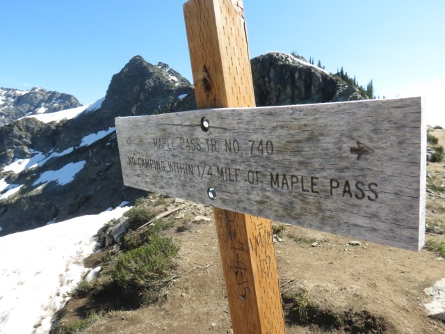
Finally, 3 miles and 2.5 hours in, we reached the top. There wasn’t much there but a trail sign and a sign marking the North Cascades national park boundary. We stopped for about 10 minutes to eat lunch, which consisted of boiled eggs a banana and an orange. The flies and the late hour (around 4 pm) kept us from spending more time here.


The descent had a lot more snow, which made it hard to follow the trail. At one point, a sharp turn was obscured by a snow field, so we kept going straight instead. When we didn’t see a trail at the end of the snow field, we back-tracked until we saw a hiker coming up. I was getting quite nervous at this point, and was ready to get to lower elevation. The descent was much less steep but the trail was still tricky to navigate due to all the loose rock. It seemed like the way was so much longer!

We kept seeing people going up the trail now, and it was past 5 pm at this point. Even though sunset was not until 4 hours later, shadows were definitely starting to creep in, and we both thought those guys would have to be quite quick to make it up and down before dark. Once we found ourselves back in the forest, we knew we were getting close. There were a few downed trees we had to climb over too. When we got to the trailhead, we were both exhausted and ready to get the heck out of there.
Pingback: Deception Pass Deja Vu - Balabanova All Over
Pingback: The Ultimate 10-Day WA National Parks Itinerary - Balabanova All Over
Pingback: Intro to Mt Baker - Balabanova All Over